The Geospatial Digital Twin Platform That Connects Every Asset, Every Team, Every Decision
usBIM.geotwin brings openBIM and GIS into one live, two-way environment — so governments, infrastructure owners, consultants, and contractors always work from the same trusted, current data. Powered by ACCA software and Esri ArcGIS technology. Guided by Isotech across every step of your digital transformation.
Free Viewer — Permanent, No Expiry. Access BIM model visualisation, point cloud support, GIS map integration, and 2GB cloud storage. No credit card. No time limit. Scale to full enterprise geospatial digital twin integration whenever your project demands it.
The Problem Is Not Data.
It Is Data That Does Not Connect
Across the GCC and wider region, ambitious programmes — Saudi Vision 2030, UAE Net Zero 2050, giga-developments from NEOM to Dubai — are placing unprecedented demands on how infrastructure is planned, delivered, and operated.
Yet most organisations still manage BIM models, GIS layers, operations data, and asset records in separate, disconnected systems.
That disconnect costs time. It creates coordination risk. It means decisions get made on incomplete information at precisely the moments when clarity matters most.
usBIM.geotwin eliminates that gap entirely.
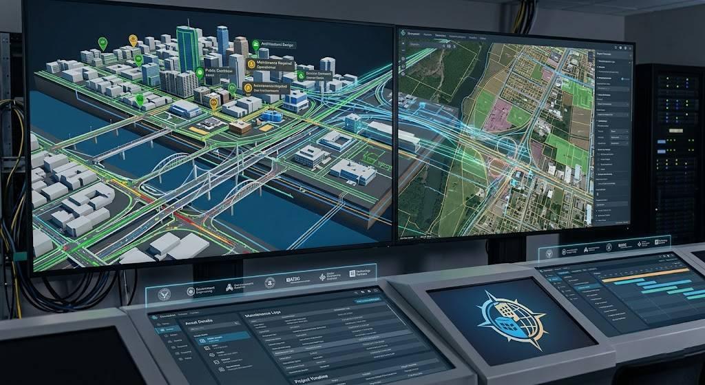
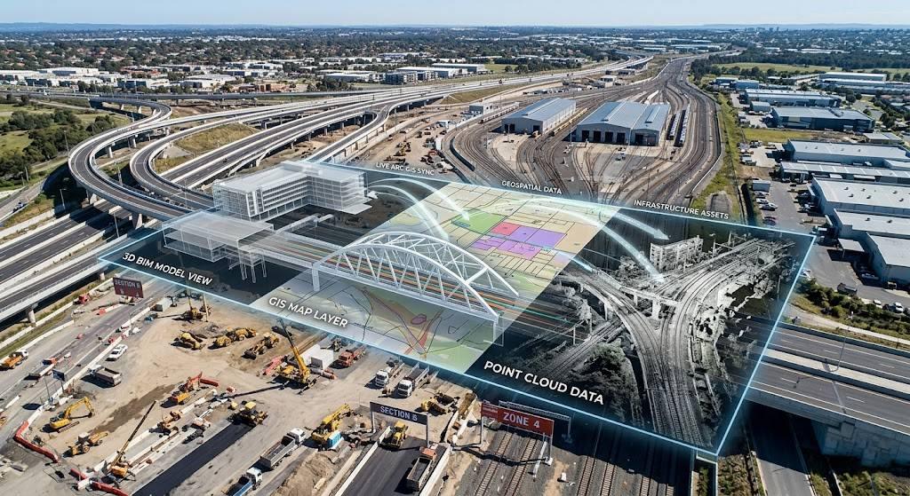
As a fully integrated geospatial digital twin platform, it creates a live, two-way connection between your openBIM environment and Esri ArcGIS — so every model, every update, and every spatial query is always current, always accurate, and always available to every authorised stakeholder.
This is not a one-time data sync. It is a continuously evolving GIS digital twin of your assets, updated in real time from first design through to long-term operations.
What Makes usBIM.geotwin Different
Real BIM-GIS Integration. Not Just a Connection.
Most geospatial BIM platforms force a choice: BIM intelligence or geographic intelligence. BIM knows everything about a building. GIS knows where it sits and what surrounds it. But in most systems, they rarely talk to each other without manual exports, format conversions, and workflow disruption.
usBIM.geotwin removes that limitation entirely. Every IFC model, point cloud, and infrastructure element is instantly geolocated and accessible within a live GIS environment. Changes made by any team member — architect, MEP consultant, surveyor, or contractor — synchronise dynamically across the platform without any manual transfer.
All stakeholders, from national ministries to on-site construction teams, work from the same source of geospatial BIM data. In real time. Always.
Dynamic two-way BIM-GIS integration
No imports, no exports
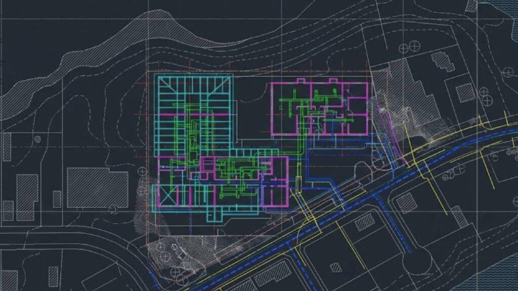
Full IFC interoperability:
IFC 2x3, 4.0, and 4.3 supported
Native point cloud & textured mesh support
Native point cloud and textured mesh support
Live federated model
Live federated model coordination across disciplines
2D and 3D BIM model
Spatial queries with immediate 2D and 3D BIM model responses
BCF issue & collaborative design review
BCF issue management and collaborative design review
Built for National Infrastructure Scale. No Limits.
From airport terminals and rail corridors to utility networks and urban districts, usBIM.geotwin handles the data volumes, federated model complexity, and multidisciplinary coordination demands that reflect how large infrastructure projects actually work — not artificially constrained versions of them.
The region is investing over US$900 billion in smart infrastructure by 2032. usBIM.geotwin is built for exactly that scale.
Roads, Railways & Utilities
Roads, railways, bridges, tunnels, and utilities — any linear infrastructure at any scale.
Federated BIM Coordination
Large-scale federated BIM coordination across distributed teams and disciplines.
IFC Compliance
IFC 2x3, 4.0, and 4.3 compliance — fully aligned to international openBIM standards.
Cloud Collaboration
High-performance cloud collaboration with real-time synchronisation.
On-Premise Deployment
On-premise deployment for sovereign infrastructure and government data environments.
GDPR Security
GDPR-compliant data protection with full audit trail and access control.
Mobile + Multilingual Access
Multilingual interface and full mobile access for field and distributed teams.
Open Standards. Your Data Stays Yours.
With usBIM.geotwin, there is no vendor lock-in. Because the platform is built entirely on open formats — IFC, openBIM, and Iso-aligned workflows — your geospatial BIM data remains accessible, portable, and usable for decades. Any stakeholder, any authoring tool, at any project stage.
For government infrastructure owners managing assets with 30 or 50-year operational lifespans, this is a strategic safeguard: your digital investment is protected regardless of how the technology landscape evolves.

From Design to Operations. One Continuous Geospatial Digital Twin Workflow.
The true value of a smart city digital twin platform is realised after construction completes — and most platforms are not designed for that reality.
usBIM.geotwin runs through every phase: planning, design, construction, operations, and long-term asset management. Every change in the BIM environment is reflected in the GIS digital twin the moment it happens. IoT sensor data feeds directly into the geospatial model. Facility Management systems stay connected throughout the operational life of every asset.
Sustainability Built In
For asset operators pursuing UAE Net Zero 2050 and Saudi Vision 2030 targets, real-time energy monitoring and infrastructure performance tracking are built into the platform — not optional extras.
What Is a Geospatial Digital Twin?
A geospatial digital twin is a live digital model of a building, infrastructure asset, or urban environment — enriched with precise GIS location data and connected to real-world systems, sensors, and operational data streams.
A standard BIM model shows you what an asset looks like. A GIS digital twin shows you where that asset sits, how it performs, and how it interacts with everything around it — continuously, not just at design completion.
A city digital twin or urban digital twin takes that further: it connects the full fabric of buildings, roads, utilities, public spaces, and infrastructure into one integrated geospatial environment — making it queryable, simulatable, and governable at city or district scale.
usBIM.geotwin delivers all three through a single geospatial digital twin software platform, integrated with Esri ArcGIS technology — making it the leading choice for organisations building digital twin with ArcGIS capability.
Why It Matters
Already Powering Smart Cities. Ready for the Middle East.
Government bodies, urban planners, and infrastructure developers around the world are already deploying usBIM.geotwin as their city digital twin platform of choice.
Isotech brings the same geospatial digital twin software capability to the Middle East and Africa — with the regional implementation expertise, local market knowledge, and human-centred guidance that complex programmes in this market require.
Urban digital twin deployed for large-scale smart city infrastructure and real-time municipal planning.
openBIM-GIS integration enabling spatial analysis and coordinated city-wide planning.
Municipal infrastructure connected to a live GIS environment for continuous oversight.
IFC model integrated into geospatial context for resource and facility planning.
Technology Without Guidance Is Just Software.
The future of the built environment depends on interoperability, collaboration, and intelligent data ecosystems. By connecting openBIM, GIS, IoT, AI, and cloud collaboration, geospatial digital twins are bringing the smart cities of tomorrow to life, today.
— Guido Cianciulli, CEO, ACCA softwareSuccessful geospatial digital twin implementation depends on people and processes as much as platform capability. Every organisation arrives at this journey from a different starting point — and in the Middle East, where geospatial BIM adoption is still maturing across sectors, that starting point matters enormously.
Isotech does not hand over software and move on. As the regional implementation partner for ACCA software across the Middle East and Africa, we coach and support clients through every stage of digital transformation — from initial scoping and environment configuration to workflow integration and long-term support.
What Isotech Provides
Global Expertise + Regional Implementation
ACCA software is the world’s number one IFC-certified openBIM expert with the largest number of IFC-certified BIM software solutions globally. Combined with Isotech’s regional knowledge and implementation capability, organisations gain both technology leadership and local execution support.
Start Today. No Commitment Required.
Free Viewer — Permanent. No Expiry. No Credit Card.
Organisations can begin using usBIM.geotwin immediately — cloud-based access, BIM model visualisation, point cloud support, GIS map integration, and 2GB storage, at no cost and with no time limit.
When your project is ready for full enterprise geospatial digital twin integration — including live two-way synchronisation with Esri ArcGIS Online or ArcGIS Enterprise — the Isotech team will assess your requirements and configure the right environment for your infrastructure context, team structure, and long-term goals.
Questions Worth Answering Up Front
What is the difference between a geospatial digital twin and a standard digital twin?
A standard digital twin is a digital replica of a physical asset. A geospatial digital twin adds the geographic dimension — placing every asset in its precise real-world spatial context and connecting it to the infrastructure and environment surrounding it. This makes it far more powerful for planning, operations, and infrastructure management, because every query and simulation is grounded in geographic reality rather than an abstract model.
What is a digital twin with ArcGIS and how does usBIM.geotwin use it?
usBIM.geotwin creates a live, two-way connection between ACCA’s openBIM platform and Esri’s ArcGIS environment — either ArcGIS Online or ArcGIS Enterprise. Changes in the BIM model update the GIS in real time. Geospatial queries return real BIM data. It is a genuinely integrated environment, not a periodic data export between separate systems.
Does usBIM.geotwin support data sovereignty and government compliance?
Yes. usBIM.geotwin is GDPR-compliant and offers optional on-premise deployment for government entities and infrastructure owners with strict data governance requirements — so organisations can advance digitally without compromising control, confidentiality, or operational security.
How does Isotech support implementation across the Middle East?
Isotech provides end-to-end coaching and implementation support — from initial scoping and geospatial BIM workflow design to team training, multilingual onboarding, and long-term technical assistance. We bring regional project context, local regulatory knowledge, and GCC market experience to every engagement, because successful digital transformation in this region depends as much on people and guidance as it does on platform capability.
The Middle East's Infrastructure Future Needs Connected Intelligence.
usBIM.geotwin combines openBIM collaboration, GIS digital twin intelligence, cloud connectivity, and lifecycle asset management into one scalable smart city digital twin platform — designed for the national infrastructure programmes, urban digital twin ambitions, and giga-developments defining this region’s future.
Whether delivering a new city district, building a city digital twin for a national infrastructure authority, or modernising long-term asset management, ACCA software and Isotech provide the technology, the open standards, and the strategic partnership required for lasting success.
“Technology creates possibilities. Relationships create successful outcomes.”

Technology Partner
We are proud to partner with ACCA Software, a global provider of BIM, digital construction, and Common Data Environment (CDE) solutions. Through this collaboration, we leverage advanced technologies that support ISO 19650-compliant workflows, streamline project coordination, and enhance information management across the entire project lifecycle.
This partnership enables us to deliver innovative, scalable, and industry-aligned solutions that help clients improve collaboration, efficiency, and project outcomes.